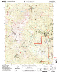
2001 Map of Bonanza
USGS Topo · Published 2005About this map
Bonanza serves as the focal point for this mining district, situated where the high-elevation terrain of the San Isabel National Forest meets the Rio Grande and Gunnison National Forest. The landscape is a dense network of silver and base-metal extraction sites, from the northern Kismuth Mine near The Gate to the concentrated workings of the Rawley Mines, Cocomongo Mine, and St Louis Mine surrounding the settlement. The map reveals the heavy industrial infrastructure required for high-altitude mining, including the Little Bonanza Mill and several Tailings Ponds. Beyond the industrial activity, the high country is defined by the Continental Divide and prominent summits like Antora Peak and Sheep Mountain. Historical transport routes such as the Rainbow Trail and the Toll Road Gulch provide evidence of early access through these mountain passes.
Find a feature on this map
76 named features on this map. Tap any name to fly to it.
Don’t see what you’re looking for? This feature index may not catch every label — zoom into the map to look around manually.
Map Details
Editions of this 2001 Bonanza Map
This is the sole edition of this map. No revisions or reprints were ever made.
Other maps of this area

1956 · Montrose
USGS Topo · 1:250,000

1959 · Montrose
USGS Topo · 1:250,000

1959 · Bonanza
USGS Topo · 1:62,500

1960 · Montrose
USGS Topo · 1:250,000

1967 · Lake Mountain NE
USGS Topo · 1:24,000

1967 · Chester
USGS Topo · 1:24,000

1967 · Pahlone Peak
USGS Topo · 1:24,000
1967 · Klondike Mine
USGS Topo · 1:24,000
1967 · Graveyard Gulch
USGS Topo · 1:24,000

1968 · Montrose
USGS Topo · 1:250,000