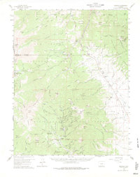
1959 Map of Bonanza
USGS Topo · Published 1977About this map
The high-altitude mining district surrounding Bonanza and the Kerber City site dominates this late 1950s survey of the Saguache and Chaffee county line. The landscape is heavily marked by late 19th-century silver-mining infrastructure, featuring an extensive network of named mines like the Rawley Mine, Cocomongo Mine, and Minnie Lynch Mine. The presence of the Superior Mill and Little Bonanza Mill alongside the local Graveyard provides a clear view of the industrial and social footprint of these isolated mountain communities.
Find a feature on this map
118 named features on this map. Tap any name to fly to it.
Don’t see what you’re looking for? This feature index may not catch every label — zoom into the map to look around manually.
Map Details
Editions of this 1959 Bonanza Map
5 editions found
Other maps of this area

1940 · Garfield
USGS Topo · 1:62,500

1945 · Garfield
USGS Topo · 1:62,500

1954 · Pueblo
USGS Topo · 1:250,000

1956 · Cameron Mountain
USGS Topo · 1:62,500

1956 · Poncha Springs
USGS Topo · 1:62,500

1956 · Montrose
USGS Topo · 1:250,000

1957 · Pueblo
USGS Topo · 1:250,000

1958 · Pueblo
USGS Topo · 1:250,000

1959 · Montrose
USGS Topo · 1:250,000

1959 · Bonanza
USGS Topo · 1:62,500