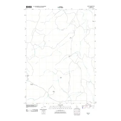
2010 Map of Bone
USGS Topo · Published 2010About this map
Bone serves as the central point of interest in this high-altitude landscape of eastern Idaho, where a network of remote roads and watercourses defines the terrain. The small settlement is situated at a critical junction near Canyon Creek and Willow Creek, anchored by the historical utility of Bone Rd. The surrounding environment is characterized by significant topographical features such as Birch Creek Mountain, Ziegler Mountain, and the Coyote Ridge divide. Water management is evident through the presence of Bohn Dam and Birch Creek Dam, which regulate the flow of the many creeks that drain this high country. Farther south and west, the landscape drops toward Sellars Creek and the Double W Divide, illustrating the complex drainage patterns that lead toward larger basins. This survey provides a clear view of the ranching and mountainous geography that defines the region at the start of the 21st century.
Find a feature on this map
25 named features on this map. Tap any name to fly to it.
Don’t see what you’re looking for? This feature index may not catch every label — zoom into the map to look around manually.
Map Details
Editions of this 2010 Bone Map
This is the sole edition of this map. No revisions or reprints were ever made.
Other maps of this area

1917 · Cranes Flat
USGS Topo · 1:62,500

1918 · Paradise Valley
USGS Topo · 1:62,500

1924 · Hell Creek
USGS Topo · 1:62,500

1924 · Ammon
USGS Topo · 1:62,500

1926 · Hell Creek
USGS Topo · 1:62,500

1955 · Driggs
USGS Topo · 1:250,000

1958 · Driggs
USGS Topo · 1:250,000

1962 · Driggs
USGS Topo · 1:250,000
1963 · Bone
USGS Topo · 1:24,000
1981 · Miner Creek
USGS Topo · 1:24,000