
1962 Map of Driggs
USGS Topo · Published 1962About this map
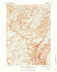
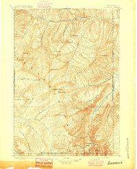
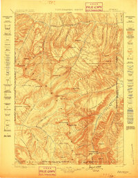
The Teton Range dominates the center of this 1962 survey, showcasing the high-altitude landscape of the Idaho-Wyoming borderlands before modern development. To the east, the National Elk Refuge and Grand Teton National Park preserve the valley floor around Jackson, while the western slopes descend toward the agricultural communities of the Teton Valley, including Driggs, Victor, and Tetonia. The map records the crucial water networks of the Snake River and its South Fork, including the newly established Palisades Reservoir. This era captures the region's connectivity via the Union Pacific RR reaching into Rexburg and St Anthony, supporting the grain and timber economies of the Targhee National Forest and Caribou National Forest. Traces of earlier resource extraction appear in labels for various prospects and gravel pits scattered across the mountain flanks.
Find a feature on this map
252 named features on this map. Tap any name to fly to it.
Don’t see what you’re looking for? This feature index may not catch every label — zoom into the map to look around manually.
Map Details
Editions of this 1962 Driggs Map
This is the sole edition of this map. No revisions or reprints were ever made.
Other maps of this area

1885 · Lake
USGS Topo · 1:125,000

1886 · Shoshone
USGS Topo · 1:125,000

1888 · Shoshone
USGS Topo · 1:125,000
1893 · Ishawooa
USGS Topo · 1:125,000

1895 · Shoshone
USGS Topo · 1:125,000
1895 · Ishawooa
USGS Topo · 1:125,000

1895 · Lake
USGS Topo · 1:125,000

1896 · Lake
USGS Topo · 1:125,000
1899 · Ishawooa
USGS Topo · 1:125,000

1899 · Grand Teton
USGS Topo · 1:125,000