
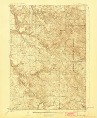
1926 Map of Hell Creek
USGS Topo · Published 1926About this map
Dehlin and its surrounding ranching country define this corner of Southeast Idaho in the mid-1920s. The landscape is a complex network of high ridges and deep drainage basins, anchored by the Caribou National Forest to the east and the Boise Base Line bisecting the quadrangle. Early 20th-century civic life is visible in the placement of the Dehlin School and the Pipe Creek School, situated near the headwaters of the many creeks that feed the regional watershed.
Find a feature on this map
35 named features on this map. Tap any name to fly to it.
Don’t see what you’re looking for? This feature index may not catch every label — zoom into the map to look around manually.
Map Details
Editions of this 1926 Hell Creek Map
2 editions found
Other maps of this area

1917 · Cranes Flat
USGS Topo · 1:62,500

1918 · Paradise Valley
USGS Topo · 1:62,500

1924 · Hell Creek
USGS Topo · 1:62,500

1924 · Ammon
USGS Topo · 1:62,500

1932 · Irwin
USGS Topo · 1:96,000

1935 · Irwin
USGS Topo · 1:125,000

1943 · Garns Mtn
USGS Topo · 1:62,500

1946 · Garns Mtn
USGS Topo · 1:62,500

1950 · Rigby
USGS Topo · 1:62,500

1950 · Rigby SE
USGS Topo · 1:24,000