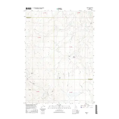
2017 Map of Bone
USGS Topo · Published 2017About this map
Bone occupies a high-desert landscape where the Blackfoot Mountains meet the vast Willow Creek Lava Field. This 2017 survey details a remote portion of Bonneville and Bingham counties, defined by the drainage systems of Birch Cr, Willow Cr, and the Grays Lake Outlet. The map illustrates a rugged topography of ridges and peaks, including Birch Creek Mtn, Ziegler Mtn, and the distinctive Coyote Ridge. Transportation through these highlands relies on established corridors like Bone RD and Sellers Creek RD, which follow the natural contours of the land. The presence of Wolverine Canyon and the numerous named creeks, such as Noon Cr and Rock Cr, highlights the complex hydrology of this part of Idaho. From the high point at The Saddle to the open expanse of Long Valley, the map provides an essential record of the area's geological and human geography.
Find a feature on this map
35 named features on this map. Tap any name to fly to it.
Don’t see what you’re looking for? This feature index may not catch every label — zoom into the map to look around manually.
Map Details
Editions of this 2017 Bone Map
This is the sole edition of this map. No revisions or reprints were ever made.
Other maps of this area

1917 · Cranes Flat
USGS Topo · 1:62,500

1918 · Paradise Valley
USGS Topo · 1:62,500

1924 · Hell Creek
USGS Topo · 1:62,500

1924 · Ammon
USGS Topo · 1:62,500

1926 · Hell Creek
USGS Topo · 1:62,500

1955 · Driggs
USGS Topo · 1:250,000

1958 · Driggs
USGS Topo · 1:250,000

1962 · Driggs
USGS Topo · 1:250,000
1963 · Bone
USGS Topo · 1:24,000
1981 · Miner Creek
USGS Topo · 1:24,000