
1920 Map of Bone Spring
USGS Topo · Published 1920About this map
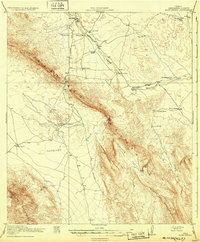
The Santiago Mountains dominate this Brewster County landscape during the first World War, revealing a network of remote ranching outposts and high-desert infrastructure. Water management is central to life here, evidenced by numerous named improvements such as Edwards Well, Cow Heaven Tank, and Norton Tank scattered across the arid terrain. Natural transit corridors are clearly defined through Persimmon Gap and Dog Canyon, providing passage through the uplifted ridges of the Sierra Del Caballo Muerto and the Rosilos Mountains.
Find a feature on this map
34 named features on this map. Tap any name to fly to it.
Don’t see what you’re looking for? This feature index may not catch every label — zoom into the map to look around manually.
Map Details
Editions of this 1920 Bone Spring Map
2 editions found
Other maps of this area

1903 · Chisos Mountains
USGS Topo · 1:125,000

1905 · Chisos Mountains
USGS Topo · 1:125,000

1917 · Santiago Peak
USGS Topo · 1:62,500

1917 · Bone Spring
USGS Topo · 1:62,500

1917 · Hood Spring
USGS Topo · 1:62,500

1918 · Bone Spring
USGS Topo · 1:125,000

1918 · Hood Spring
USGS Topo · 1:62,500

1918 · Dove Mountain
USGS Topo · 1:62,500

1918 · Santiago Peak
USGS Topo · 1:62,500

1918 · Bone Spring
USGS Topo · 1:62,500