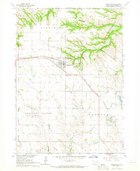
1964 Map of Bonesteel
USGS Topo · Published 1965About this map
Bonesteel and Fairfax serve as the primary hubs in this corner of Gregory County, situated along the Chicago and North Western railroad corridor. The landscape is defined by the sharp transition between the agricultural plateaus and the dissected breaks leading toward the Missouri River basin, as evidenced by the Old Fort Randall Military Reservation Boundary and the Rosebud Indian Reservation Boundary cutting across the western and northern sections.
Find a feature on this map
23 named features on this map. Tap any name to fly to it.
Don’t see what you’re looking for? This feature index may not catch every label — zoom into the map to look around manually.
Map Details
Editions of this 1964 Bonesteel Map
This is the sole edition of this map. No revisions or reprints were ever made.
Other maps of this area

1951 · Butte NW
USGS Topo · 1:24,000

1951 · Naper
USGS Topo · 1:24,000

1955 · Mitchell
USGS Topo · 1:250,000

1955 · O'Neill
USGS Topo · 1:250,000

1959 · O'Neill
USGS Topo · 1:250,000

1959 · Mitchell
USGS Topo · 1:250,000

1964 · Campbell Creek
USGS Topo · 1:24,000

1964 · Butte
USGS Topo · 1:24,000

1964 · Herrick NE
USGS Topo · 1:24,000

1964 · St. Charles
USGS Topo · 1:24,000