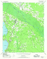
1943 Map of Bonneau
USGS Topo · Published 1969About this map
Santee River and the massive Santee Swamp dominate this wartime landscape, illustrating a region defined by its complex hydrology and timber industry. To the west, the recently formed Lake Moultrie creates a new shoreline at Richardson Landing, while the interior remains a dense network of blackwater swamps like Walleye Swamp and Spring Grove Swamp. The importance of military and logistical infrastructure during the early 1940s is evident in the presence of the Lane Auxiliary Airfield and the Bonneau Fire Tower, alongside the vital Atlantic Coast Line railroad corridor.
Find a feature on this map
91 named features on this map. Tap any name to fly to it.
Don’t see what you’re looking for? This feature index may not catch every label — zoom into the map to look around manually.
Map Details
Editions of this 1943 Bonneau Map
2 editions found

Other maps of this area

1919 · Summerville
USGS Topo · 1:48,000

1919 · Cordesville
USGS Topo · 1:48,000

1920 · Chicora
USGS Topo · 1:48,000

1920 · Manning
USGS Topo · 1:48,000

1920 · Summerville
USGS Topo · 1:62,500

1921 · Chicora
USGS Topo · 1:62,500

1921 · Manning
USGS Topo · 1:62,500

1943 · Chicora
USGS Topo · 1:62,500

1943 · Shulerville
USGS Topo · 1:24,000

1943 · Trio
USGS Topo · 1:24,000