
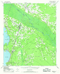
1943 Map of Bonneau
USGS Topo · Published 1964About this map
Santee River and the vast Santee Swamp dominate this Berkeley County landscape, revealing a region defined by its complex waterways and the timber industry. The Santee River Logging RR and the Russellville Lumber Company Road provide evidence of the heavy logging operations that moved through the bottomlands during this era. Along the western edge, the recently formed Lake Moultrie reshaped the local geography, with Richardson Landing providing access to the new shoreline.
Find a feature on this map
86 named features on this map. Tap any name to fly to it.
Don’t see what you’re looking for? This feature index may not catch every label — zoom into the map to look around manually.
Map Details
Editions of this 1943 Bonneau Map
2 editions found
Other maps of this area

1919 · Summerville
USGS Topo · 1:48,000

1919 · Cordesville
USGS Topo · 1:48,000

1920 · Chicora
USGS Topo · 1:48,000

1920 · Manning
USGS Topo · 1:48,000

1920 · Summerville
USGS Topo · 1:62,500

1921 · Chicora
USGS Topo · 1:62,500

1921 · Manning
USGS Topo · 1:62,500

1943 · Chicora
USGS Topo · 1:62,500

1943 · Shulerville
USGS Topo · 1:24,000

1943 · Trio
USGS Topo · 1:24,000