
1943 Map of Chicora
USGS Topo · Published 1943About this map
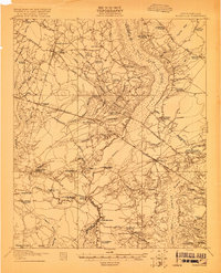
The Francis Marion Tomb serves as a historic anchor for this Berkeley County landscape, which is defined by the complex hydrology of the Santee River and early infrastructure like the Santee Canal. In this era before the full realization of the Santee Cooper project, the map reveals a terrain of extensive swamp basins and depressions known as bays, such as Pigeon Bay and Bulltown Bay. The settlement pattern is largely rural and dispersed, with community life centered on numerous small institutions like St Lukes Ch, Jerusalem Ch, and the Whitebridge Sch.
Find a feature on this map
70 named features on this map. Tap any name to fly to it.
Don’t see what you’re looking for? This feature index may not catch every label — zoom into the map to look around manually.
Map Details
Editions of this 1943 Chicora Map
This is the sole edition of this map. No revisions or reprints were ever made.
Other maps of this area

1919 · Summerville
USGS Topo · 1:48,000
1919 · Ridgeville
USGS Topo · 1:48,000

1919 · Cordesville
USGS Topo · 1:48,000

1920 · Eutawville
USGS Topo · 1:48,000

1920 · Chicora
USGS Topo · 1:48,000

1920 · Manning
USGS Topo · 1:48,000
1920 · Ridgeville
USGS Topo · 1:62,500

1920 · Summerville
USGS Topo · 1:62,500
1921 · Chicora
USGS Topo · 1:62,500
1921 · Manning
USGS Topo · 1:62,500