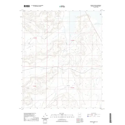
2020 Map of Bookout Ranch
USGS Topo · Published 2020About this map
Bookout Ranch sits at the heart of this high-plains landscape in eastern San Miguel County, where ranching life is defined by the ephemeral drainage systems and mesas of the Llano Estacado region. The map reveals a network of watercourses including Garita Cr, Cuervo Cr, and Pino Cr, which carve through the terrain to shape prominent landforms like North Mesa. This modern survey illustrates the reach of rural infrastructure through county roads such as Co RD C-59 and residential markers like Aztec Vista Dr. The land is meticulously partitioned by the Public Land Survey System, with township and range lines like t13n r25e overlaying the natural topography. This document provides a clear view of contemporary land use in a region where wide-open spaces and water rights are central to the local economy.
Find a feature on this map
16 named features on this map. Tap any name to fly to it.
Don’t see what you’re looking for? This feature index may not catch every label — zoom into the map to look around manually.
Map Details
Editions of this 2020 Bookout Ranch Map
This is the sole edition of this map. No revisions or reprints were ever made.
Other maps of this area

1954 · Santa Fe
USGS Topo · 1:250,000

1958 · Santa Fe
USGS Topo · 1:250,000

1963 · Mesita Del Gato
USGS Topo · 1:24,000

1964 · Neafus Ranch
USGS Topo · 1:24,000

1964 · Ortega Tank
USGS Topo · 1:24,000

1967 · Tenaja Mesa
USGS Topo · 1:24,000

1968 · Conchas Dam
USGS Topo · 1:24,000

1972 · Variadero
USGS Topo · 1:24,000

1972 · Four V Ranch
USGS Topo · 1:24,000

1972 · La Silla
USGS Topo · 1:24,000