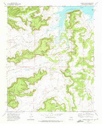
1972 Map of Bookout Ranch
USGS Topo · Published 1975About this map
Bookout Ranch and the surrounding high desert of San Miguel County are defined by a network of seasonal watercourses flowing toward the southern reaches of Conchas Lake. This early 1970s landscape is largely shaped by the cattle industry, where the rugged topography of North Mesa and the expansive Pablo Montoya grant land dictate the placement of ranching outposts. Evidence of earlier habitation is found at Chavez (Ruins) near the banks of Cuervo Creek, while a small Cem remains as a quiet marker of the families who settled this arid terrain. The map details the drainage patterns of Garita Creek, Pino Creek, and Manga Creek, illustrating how the geography of the Pecos River basin transitions into the reservoir system. These labels provide essential context for understanding the 20th-century ranching life and the enduring legacy of Spanish land grants in New Mexico.
Find a feature on this map
12 named features on this map. Tap any name to fly to it.
Don’t see what you’re looking for? This feature index may not catch every label — zoom into the map to look around manually.
Map Details
Editions of this 1972 Bookout Ranch Map
This is the sole edition of this map. No revisions or reprints were ever made.
Other maps of this area

1954 · Santa Fe
USGS Topo · 1:250,000

1958 · Santa Fe
USGS Topo · 1:250,000

1963 · Mesita Del Gato
USGS Topo · 1:24,000

1964 · Neafus Ranch
USGS Topo · 1:24,000

1964 · Ortega Tank
USGS Topo · 1:24,000

1967 · Tenaja Mesa
USGS Topo · 1:24,000

1968 · Conchas Dam
USGS Topo · 1:24,000

1972 · Variadero
USGS Topo · 1:24,000

1972 · Four V Ranch
USGS Topo · 1:24,000

1972 · La Silla
USGS Topo · 1:24,000