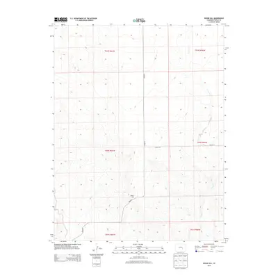
2013 Map of Boone Hill
USGS Topo · Published 2013About this map
Boone Hill stands as the primary topographical landmark in this section of Pueblo County, rising amidst a landscape defined by the drainage patterns of eastern Colorado. The terrain is etched by the meandering courses of Kramer Cr and Haynes Cr, which carve through the open country. This 2013 survey illustrates a sparsely populated region where rural transit is facilitated by routes such as Boone Rd and Asbridge Rd. The map provides a precise layout of the Public Land Survey System, showing the township and range divisions including t020s r061w and t020s r060w. This grid-based organization highlights the legacy of Western land management and homesteading patterns that still govern the physical and legal boundaries of the plains today.
Find a feature on this map
12 named features on this map. Tap any name to fly to it.
Don’t see what you’re looking for? This feature index may not catch every label — zoom into the map to look around manually.
Map Details
Editions of this 2013 Boone Hill Map
This is the sole edition of this map. No revisions or reprints were ever made.
Other maps of this area

1891 · Nepesta
USGS Topo · 1:125,000

1893 · Nepesta
USGS Topo · 1:125,000

1904 · Nepesta
USGS Topo · 1:125,000

1954 · Pueblo
USGS Topo · 1:250,000

1957 · Pueblo
USGS Topo · 1:250,000

1958 · Pueblo
USGS Topo · 1:250,000

1959 · Highlands Church
USGS Topo · 1:24,000
1959 · Grandview School
USGS Topo · 1:24,000

1959 · North Avondale NE
USGS Topo · 1:24,000
1960 · Nepesta
USGS Topo · 1:24,000