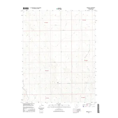
2016 Map of Boone Hill
USGS Topo · Published 2016About this map
Boone Hill rises as the central topographic feature in this part of Pueblo County, providing a clear view of the rural landscape structured by the Public Land Survey System. The area is defined by its sectional grid, where long county roads like Co Rd 611 and Co Rd 3619 cut through the open country. The natural drainage of Kramer Cr winds through the eastern sections, creating a subtle contrast to the straight-line geometry of the property boundaries. This 2016 survey captures the enduring agricultural character of the region, where the naming of Boone Hill E Rd reflects the local importance of the namesake landform. The map serves as a record of modern land management in a high-plains environment, documenting the network of remote roads such as Co Rd 3640 that connect isolated sections of the township and range system.
Find a feature on this map
14 named features on this map. Tap any name to fly to it.
Don’t see what you’re looking for? This feature index may not catch every label — zoom into the map to look around manually.
Map Details
Editions of this 2016 Boone Hill Map
This is the sole edition of this map. No revisions or reprints were ever made.
Other maps of this area

1891 · Nepesta
USGS Topo · 1:125,000

1893 · Nepesta
USGS Topo · 1:125,000

1904 · Nepesta
USGS Topo · 1:125,000

1954 · Pueblo
USGS Topo · 1:250,000

1957 · Pueblo
USGS Topo · 1:250,000

1958 · Pueblo
USGS Topo · 1:250,000

1959 · Highlands Church
USGS Topo · 1:24,000
1959 · Grandview School
USGS Topo · 1:24,000

1959 · North Avondale NE
USGS Topo · 1:24,000
1960 · Nepesta
USGS Topo · 1:24,000