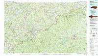
1985 Map of Boone
USGS Topo · Published 1986About this map
Boone and the high country of the Blue Ridge Mountains define this mid-1980s survey, showing the expansion of Appalachian State University alongside traditional mountain communities. The landscape is a network of ridges and river headwaters, where the Watauga River and South Fork New River begin their descent. The Blue Ridge Parkway snakes through the center of the sheet, connecting protected lands like Julian Price Memorial Park and Moses H Cone Memorial Park. To the east, the terrain descends toward Wilkesboro and the W. Kerr Scott Reservoir, marking the transition from the high peaks to the foothills. This era shows the developed corridors of Us 421 and Us 321 linking smaller mountain settlements such as Valle Crucis, Banner Elk, and Sugar Grove, reflecting the region's long-standing role as a crossroads for both education and timber history.
Find a feature on this map
185 named features on this map. Tap any name to fly to it.
Don’t see what you’re looking for? This feature index may not catch every label — zoom into the map to look around manually.
Map Details
Editions of this 1985 Boone Map
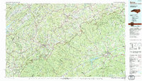
2 editions found
Other maps of this area

1889 · Hillsville
USGS Topo · 1:125,000

1889 · Wytheville
USGS Topo · 1:125,000

1889 · Wilkesboro
USGS Topo · 1:125,000

1891 · Roan Mountain
USGS Topo · 1:125,000

1891 · Abingdon
USGS Topo · 1:125,000

1891 · Wilkesboro
USGS Topo · 1:125,000

1891 · Yadkinville
USGS Topo · 1:125,000

1892 · Hillsville
USGS Topo · 1:125,000

1892 · Wytheville
USGS Topo · 1:125,000

1893 · Cranberry
USGS Topo · 1:125,000