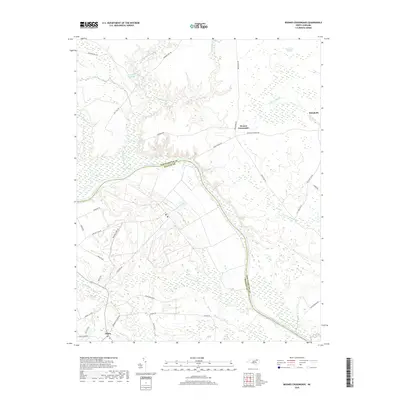
2019 Map of Boones Crossroads
USGS Topo · Published 2019About this map
The Roanoke River serves as the prominent natural boundary between Northampton Co and Halifax Co, carving a winding path through a landscape defined by extensive wetlands and low-lying drainage basins. Near the northern reach, Barrows Millpond and Lilly Pond Cr feed into the broader river system, while the eastern section is dominated by the sprawling reaches of Urahaw Swamp and Quarter Swamp. This geography dictated the placement of small rural crossroads like Boones Crossroads and the settlement at Rehoboth, which remain connected by long-established routes such as Rehoboth Church Rd.
Find a feature on this map
39 named features on this map. Tap any name to fly to it.
Don’t see what you’re looking for? This feature index may not catch every label — zoom into the map to look around manually.
Map Details
Editions of this 2019 Boones Crossroads Map
This is the sole edition of this map. No revisions or reprints were ever made.
Other maps of this area

1953 · Norfolk
USGS Topo · 1:250,000

1960 · Dawson Crossroads
USGS Topo · 1:24,000

1962 · Scotland Neck
USGS Topo · 1:24,000

1962 · Norfleet
USGS Topo · 1:24,000

1974 · Halifax
USGS Topo · 1:24,000

1974 · Boones Crossroads
USGS Topo · 1:24,000

1974 · Rich Square
USGS Topo · 1:24,000
1974 · Weldon
USGS Topo · 1:24,000
1974 · Jackson
USGS Topo · 1:24,000
1975 · Galatia
USGS Topo · 1:24,000