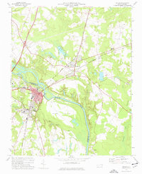
1974 Map of Weldon
USGS Topo · Published 1977About this map
Weldon and Garysburg sit positioned on opposite banks of the Roanoke River in the mid-1970s, where the shared border of Halifax and Northampton Counties follows the river's winding course. This era is defined by the heavy presence of the Seaboard Coast Line, whose rail infrastructure bisects both towns and influences the local landscape. The map reveals a community-focused geography, particularly visible in the density of institutions like Cedarwood Cemetery, Weldon High School, and numerous churches such as Oak Grove Ch and Chapel Grove Ch. South of the main river channel, the large landform known as Mush Island is separated from the mainland by the Gut, illustrating the complex hydrology of the floodplains. Industrial and municipal footprints are clear, from the Filtration Plant and Sewage Disposal sites to various extraction points like the Sandpit and Gravel Pit scattered across the surrounding terrain.
Find a feature on this map
50 named features on this map. Tap any name to fly to it.
Don’t see what you’re looking for? This feature index may not catch every label — zoom into the map to look around manually.
Map Details
Editions of this 1974 Weldon Map
This is the sole edition of this map. No revisions or reprints were ever made.
Other maps of this area

1919 · Emporia
USGS Topo · 1:62,500

1919 · Arringdale
USGS Topo · 1:48,000

1920 · Arringdale
USGS Topo · 1:62,500

1942 · Arringdale
USGS Topo · 1:62,500

1942 · Emporia
USGS Topo · 1:62,500

1953 · Norfolk
USGS Topo · 1:250,000

1963 · Skippers
USGS Topo · 1:24,000

1963 · Barley
USGS Topo · 1:24,000
1966 · Claresville
USGS Topo · 1:24,000

1974 · Halifax
USGS Topo · 1:24,000