
1942 Map of Emporia
USGS Topo · Published 1942About this map
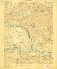
Emporia and North Emporia serve as the central hubs for this region, where the Southern and Atlantic Coast Line railroads intersect. This 1942 compilation, based on 1918 surveys and 1937 aerial photography, reveals a landscape defined by small agrarian communities and water-powered industry. Numerous family-named mills, such as Webbs Mill, Slagles Mill, and Moss Mill, are situated along the drainage basins of the Meherrin River and Fontaine Creek.
Find a feature on this map
68 named features on this map. Tap any name to fly to it.
Don’t see what you’re looking for? This feature index may not catch every label — zoom into the map to look around manually.
Map Details
Editions of this 1942 Emporia Map
This is the sole edition of this map. No revisions or reprints were ever made.
Other maps of this area

1918 · Lawrenceville
USGS Topo · 1:62,500

1919 · Jarratt
USGS Topo · 1:62,500

1919 · Mc Kenney
USGS Topo · 1:48,000

1919 · White Plains
USGS Topo · 1:48,000

1919 · Emporia
USGS Topo · 1:62,500

1919 · Arringdale
USGS Topo · 1:48,000

1920 · Lawrenceville
USGS Topo · 1:48,000

1920 · White Plains
USGS Topo · 1:62,500
1920 · Arringdale
USGS Topo · 1:62,500

1921 · Mc Kenney
USGS Topo · 1:62,500