
1919 Map of Mc Kenney
USGS Topo · Published 1919About this map
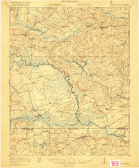
The Nottaway River serves as a winding natural boundary for several Virginia counties on this 1919 survey, including Dinwiddie, Brunswick, Greensville, and Sussex. The rural landscape is defined by its extensive network of creeks and swamps, such as Otterdam Swamp and Three Creek, which dictated the placement of important crossings like Long Bridge and Cutbank Bridge.
Find a feature on this map
72 named features on this map. Tap any name to fly to it.
Don’t see what you’re looking for? This feature index may not catch every label — zoom into the map to look around manually.
Map Details
Editions of this 1919 Mc Kenney Map
This is the sole edition of this map. No revisions or reprints were ever made.
Other maps of this area

1894 · Petersburg
USGS Topo · 1:62,500

1897 · Amelia
USGS Topo · 1:125,000

1918 · Lawrenceville
USGS Topo · 1:62,500

1919 · Jarratt
USGS Topo · 1:62,500

1919 · White Plains
USGS Topo · 1:48,000

1919 · Emporia
USGS Topo · 1:62,500

1919 · Arringdale
USGS Topo · 1:48,000

1920 · Lawrenceville
USGS Topo · 1:48,000

1920 · White Plains
USGS Topo · 1:62,500
1920 · Arringdale
USGS Topo · 1:62,500