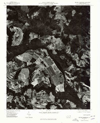
1977 Map of Boones Crossroads
USGS Topo · Published 1979About this map
Roanoke River meanders through this portion of Northampton County, defining a landscape of deep-cut drainage patterns and expansive agricultural fields. This 1977 orthophotoquad provides a clear aerial view of the rural crossroads and small communities that characterize the region. The settlement at Boones Crossroads sits amidst a network of farm roads and timbered tracts, while Rehoboth and Hillery mark other localized points of habitation. The photographic detail captures the specific layout of individual farmsteads and the sharp contrast between cleared farmland and the dense vegetation lining the riverbanks. For those studying the land use of the late 1970s, the map offers an exact record of field boundaries and forest cover before decades of subsequent growth and change.
Find a feature on this map
4 named features on this map. Tap any name to fly to it.
Don’t see what you’re looking for? This feature index may not catch every label — zoom into the map to look around manually.
Map Details
Editions of this 1977 Boones Crossroads Map
This is the sole edition of this map. No revisions or reprints were ever made.
Other maps of this area

1953 · Norfolk
USGS Topo · 1:250,000

1960 · Dawson Crossroads
USGS Topo · 1:24,000

1962 · Scotland Neck
USGS Topo · 1:24,000

1962 · Norfleet
USGS Topo · 1:24,000

1974 · Halifax
USGS Topo · 1:24,000

1974 · Boones Crossroads
USGS Topo · 1:24,000

1974 · Rich Square
USGS Topo · 1:24,000
1974 · Weldon
USGS Topo · 1:24,000
1974 · Jackson
USGS Topo · 1:24,000
1975 · Galatia
USGS Topo · 1:24,000