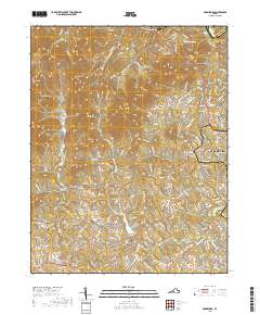
2019 Map of Boonsboro
USGS Topo · Published 2019About this map
The James River defines the northern boundary of this Piedmont landscape, carving through the gap between the Amherst and Bedford County line near Coleman Falls. To the south, the topography is dominated by a series of prominent peaks including Fleming Mtn, Rocky Mtn, and Dolly Mtn, which separate the rugged northern reaches from the developing residential patterns of Lynchburg and Boonsboro. The map reveals a transition from these wooded heights to the more settled areas around Perrowville and Norwood.
Find a feature on this map
135 named features on this map. Tap any name to fly to it.
Don’t see what you’re looking for? This feature index may not catch every label — zoom into the map to look around manually.
Map Details
Editions of this 2019 Boonsboro Map
This is the sole edition of this map. No revisions or reprints were ever made.
Other maps of this area

1892 · Lynchburg
USGS Topo · 1:125,000

1894 · Lexington
USGS Topo · 1:125,000

1935 · Buena Vista
USGS Topo · 1:48,000

1935 · Amherst
USGS Topo · 1:48,000

1939 · Amherst
USGS Topo · 1:62,500

1939 · Buena Vista
USGS Topo · 1:62,500

1940 · Buena Vista
USGS Topo · 1:62,500

1944 · Lynchburg
USGS Topo · 1:62,500

1947 · Roanoke
USGS Topo · 1:250,000

1950 · Goode
USGS Topo · 1:62,500