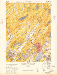
1947 Map of Boonton
USGS Topo · Published 1947About this map
Boonton and its surrounding townships in Morris County are defined by a complex hydraulic and industrial landscape in this post-war era survey. The Rockaway River winds through the central valley, feeding into the massive Boonton Reservoir and the Jersey City Reservoir, which dominate the eastern and southern terrain. In the northwest, the presence of the Hibernia Mine and the Wharton and Northern railroad reflect the region's deep ties to iron mining and mineral transport.
Find a feature on this map
58 named features on this map. Tap any name to fly to it.
Don’t see what you’re looking for? This feature index may not catch every label — zoom into the map to look around manually.
Map Details
Editions of this 1947 Boonton Map
This is the sole edition of this map. No revisions or reprints were ever made.
Other maps of this area

1888 · Franklin
USGS Topo · 1:62,500

1888 · Morristown
USGS Topo · 1:62,500

1888 · Lake Hopatcong
USGS Topo · 1:62,500

1891 · Greenwood Lake
USGS Topo · 1:62,500

1893 · Greenwood Lake
USGS Topo · 1:62,500

1894 · Morristown
USGS Topo · 1:62,500

1894 · Lake Hopatcong
USGS Topo · 1:62,500

1894 · Franklin
USGS Topo · 1:62,500

1897 · Franklin
USGS Topo · 1:62,500

1898 · Lake Hopatcong
USGS Topo · 1:62,500
Featured Places
- Parsippany-Troy Hills, NJ
- Rockaway Township, NJ
- Montville Township, NJ
- Denville, NJ
- Denville Township, Denville