
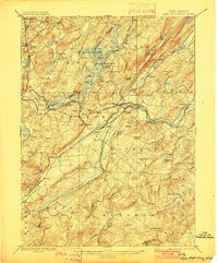
1898 Map of Lake Hopatcong
USGS Topo · Published 1898About this map
Lake Hopatcong serves as the central focal point of this late-19th-century landscape, surrounded by a burgeoning network of summer resorts and iron-mining districts. The intricate shoreline, featuring Halsey Island and Bertrand Island, is already well-defined, while the Morris Canal cuts across the terrain to connect the highlands with industrial centers to the east. Transportation is a defining characteristic of this era, with the Delaware Lackawanna and Western Railroad and various branches like the High Bridge Branch of Central Railroad of New Jersey tracing through valleys and mountain gaps to serve towns such as Dover and Stanhope.
Find a feature on this map
136 named features on this map. Tap any name to fly to it.
Don’t see what you’re looking for? This feature index may not catch every label — zoom into the map to look around manually.
Map Details
Editions of this 1898 Lake Hopatcong Map
2 editions found
Other maps of this area

1888 · Franklin
USGS Topo · 1:62,500

1888 · Plainfield
USGS Topo · 1:62,500

1888 · Morristown
USGS Topo · 1:62,500

1888 · Hackettstown
USGS Topo · 1:62,500

1888 · Lake Hopatcong
USGS Topo · 1:62,500

1890 · High Bridge
USGS Topo · 1:62,500

1891 · Somerville
USGS Topo · 1:62,500

1891 · Greenwood Lake
USGS Topo · 1:62,500

1891 · Wallpack
USGS Topo · 1:62,500

1893 · Plainfield
USGS Topo · 1:62,500
Featured Places
- Parsippany-Troy Hills, NJ
- Mount Olive, NJ
- Rockaway Township, NJ
- Roxbury Township, NJ
- Sparta Township, NJ