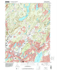
1995 Map of Boonton
USGS Topo · Published 2000About this map
Boonton and its surrounding Morris County highlands are defined by a complex network of reservoirs and protected parklands that dominate the terrain in the mid-1990s. The Rockaway River winds through the landscape, feeding into the large Boonton Reservoir and Splitrock Reservoir, which serve as central landmarks alongside the sprawling Farny State Park and Wildcat Ridge State Wildlife Management Area. The map captures the suburban character of Mountain Lakes and Denville contrasting with the heavy industrial and military footprint of the Picatinny Arsenal to the west.
Find a feature on this map
99 named features on this map. Tap any name to fly to it.
Don’t see what you’re looking for? This feature index may not catch every label — zoom into the map to look around manually.
Map Details
Editions of this 1995 Boonton Map
This is the sole edition of this map. No revisions or reprints were ever made.
Other maps of this area

1888 · Franklin
USGS Topo · 1:62,500

1888 · Morristown
USGS Topo · 1:62,500

1888 · Lake Hopatcong
USGS Topo · 1:62,500

1891 · Greenwood Lake
USGS Topo · 1:62,500

1893 · Greenwood Lake
USGS Topo · 1:62,500

1894 · Morristown
USGS Topo · 1:62,500

1894 · Lake Hopatcong
USGS Topo · 1:62,500

1894 · Franklin
USGS Topo · 1:62,500

1897 · Franklin
USGS Topo · 1:62,500

1898 · Lake Hopatcong
USGS Topo · 1:62,500
Featured Places
- Parsippany-Troy Hills, NJ
- Rockaway Township, NJ
- Montville Township, NJ
- Denville, NJ
- Denville Township, Denville