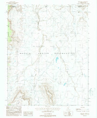
1988 Map of Boot Mesa
USGS Topo · Published 1988About this map
Hoskinnini Mesa and the high plateaus of the Navajo Indian Reservation dominate this 1980s landscape along the Arizona-Utah border. The terrain is defined by dramatic geological features like The Ramp and the massive profile of Boot Mesa rising above El Capitan Flat. Water movement is traced by the seasonal paths of Oljato Wash and El Capitan Wash, which drain the arid basins between the mesas. Evidence of mid-century industrial activity is present through scattered labels for a Mine Shaft and Open Pit Mine, indicating small-scale extraction within the reservation boundaries. This survey captures a moment when the remote borderlands relied on traditional land use alongside localized mineral exploration near landmarks like Hat Rock and Azansosi Mesa.
Find a feature on this map
13 named features on this map. Tap any name to fly to it.
Don’t see what you’re looking for? This feature index may not catch every label — zoom into the map to look around manually.
Map Details
Editions of this 1988 Boot Mesa Map
This is the sole edition of this map. No revisions or reprints were ever made.
Other maps of this area

1883 · Marsh Pass
USGS Topo · 1:250,000

1886 · Henry Mountains
USGS Topo · 1:250,000

1892 · Marsh Pass
USGS Topo · 1:250,000

1892 · Henry Mountains
USGS Topo · 1:250,000

1952 · Clay Hills 4 SW
USGS Topo · 1:24,000

1952 · Clay Hills 3 SE
USGS Topo · 1:24,000

1952 · Agathla Peak 1 NW
USGS Topo · 1:24,000

1952 · Agathla Peak 2 SW
USGS Topo · 1:24,000

1952 · Agathla Peak 2 NW
USGS Topo · 1:24,000

1952 · Boot Mesa
USGS Topo · 1:62,500