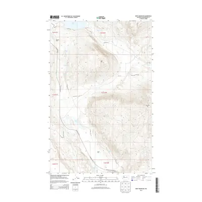
2014 Map of Boot Mountain
USGS Topo · Published 2014About this map
The Colville Indian Reservation encompasses this high plateau landscape, defined by a series of saline lakes and seasonal watercourses. The northern reaches are anchored by the expanse of Omak Lake, with Stinking Lake and Rat Lake tucked into the higher elevations to the west. This territory transitions from the southern shore of the lake through the prominent Goose Flats toward the south, where Alkali Lake and Hidden Lake mark the lower basins. The terrain is dominated by significant peaks including Boot Mtn and Whitmore Mtn, while unique geological features like Balance Rock punctuate the ridges. A network of rural routes, including Columbia River Rd and Omak Lake Rd, provides access across these tribal lands, connecting scattered water sources like Kartar Spring and Buggy Spring used for land management and local navigation.
Find a feature on this map
30 named features on this map. Tap any name to fly to it.
Don’t see what you’re looking for? This feature index may not catch every label — zoom into the map to look around manually.
Map Details
Editions of this 2014 Boot Mountain Map
This is the sole edition of this map. No revisions or reprints were ever made.
Other maps of this area

1950 · Boot Mtn
USGS Topo · 1:62,500

1950 · Alameda Flat
USGS Topo · 1:62,500

1952 · Alameda Flat
USGS Topo · 1:62,500

1952 · Disautel
USGS Topo · 1:62,500

1953 · Omak Lake
USGS Topo · 1:62,500

1954 · Okanogan
USGS Topo · 1:250,000

1958 · Okanogan
USGS Topo · 1:250,000
1980 · Camp Seven
USGS Topo · 1:24,000
1980 · Boot Mountain
USGS Topo · 1:24,000
1980 · Joe Lake
USGS Topo · 1:24,000