1958 Map of Okanogan
USGS Topo · Published 1958About this map
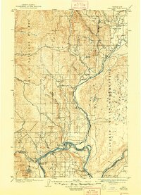
The Okanogan River valley serves as the central artery for this mid-century portrait of North Central Washington, where the Great Northern railroad tracks parallel the water through towns like Oroville and Tonasket. To the south and east, the Colville Indian Reservation encompasses a significant portion of the landscape, including the shores of Omak Lake and the Sanpoil River. The eastern edge of the sheet is dominated by the expansive Franklin D. Roosevelt Lake on the Columbia, where the settlement of Marcus stands near the confluence of the Columbia River and Hall Creek.
Find a feature on this map
103 named features on this map. Tap any name to fly to it.
Don’t see what you’re looking for? This feature index may not catch every label — zoom into the map to look around manually.
Map Details
Editions of this 1958 Okanogan Map
This is the sole edition of this map. No revisions or reprints were ever made.
Historical Maps of Omak Through Time
6 maps found