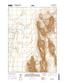
2017 Map of Borax Lake
USGS Topo · Published 2017About this map
Pueblo Valley contains a unique hydrological landscape where geothermal and mineral activity define the terrain. The presence of Borax Lake and the nearby Lower Borax Lake Reservoir highlights the area's namesake mineral history, while numerous water sources like Hot Springs, Salt Springs, and Buckbrush Spring dot the basin. The eastern portion of the map is dominated by sharp topographic rises, contrasting with the flat drainage systems of Trout Cr and the seasonal expanse of Alvord Lake to the north. Only a single named thoroughfare, Guzzler Rd, traverses this remote section of Harney County, illustrating the sparse human footprint in a region shaped primarily by geology and intermittent water flow.
Find a feature on this map
17 named features on this map. Tap any name to fly to it.
Don’t see what you’re looking for? This feature index may not catch every label — zoom into the map to look around manually.
Map Details
Editions of this 2017 Borax Lake Map
This is the sole edition of this map. No revisions or reprints were ever made.
Other maps of this area

1955 · Adel
USGS Topo · 1:250,000

1957 · Adel
USGS Topo · 1:250,000

1958 · Adel
USGS Topo · 1:250,000

1962 · Adel
USGS Topo · 1:250,000

1971 · Andrews
USGS Topo · 1:24,000

1971 · V Lake
USGS Topo · 1:24,000

1971 · Fields
USGS Topo · 1:24,000

1971 · Borax Lake
USGS Topo · 1:24,000

1981 · Tule Springs
USGS Topo · 1:24,000
1981 · Tumtum Lake
USGS Topo · 1:24,000