
1971 Map of Andrews
USGS Topo · Published 1974About this map
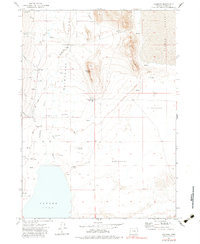
Alvord Lake and the arid expanse of the Alvord Desert dominate this Harney County landscape, where water management is the central theme of settlement. In the early 1970s, the map illustrates a network of remote homesteads and ranching outposts like the Serrano Point Ranch, Penland Ranch, and Kueny Ranch that rely on a system of Flowing Wells and a Diversion Dam on the Wildhorse Creek. The terrain is characterized by dramatic elevation shifts, from the high Serrano Point down to the vast Alvord Valley. For genealogists and local historians, the inclusion of the Cem near Wilson Creek and isolated landmarks such as Readis Homestead and McLean Place provides a clear record of the families who inhabited this high desert region before the shift toward modern land use.
Find a feature on this map
35 named features on this map. Tap any name to fly to it.
Don’t see what you’re looking for? This feature index may not catch every label — zoom into the map to look around manually.
Map Details
Editions of this 1971 Andrews Map
2 editions found
Other maps of this area

1955 · Adel
USGS Topo · 1:250,000

1957 · Adel
USGS Topo · 1:250,000

1958 · Adel
USGS Topo · 1:250,000

1962 · Adel
USGS Topo · 1:250,000

1968 · Alvord Hot Springs
USGS Topo · 1:24,000

1968 · Ankle Creek
USGS Topo · 1:24,000

1971 · V Lake
USGS Topo · 1:24,000

1971 · Fields
USGS Topo · 1:24,000

1971 · Borax Lake
USGS Topo · 1:24,000

1981 · Tule Springs
USGS Topo · 1:24,000