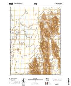
2020 Map of Borax Lake
USGS Topo · Published 2020About this map
Borax Lake and the nearby Borax Hot Springs anchor this specialized desert landscape in the Pueblo Valley. This 2020 survey documents the complex hydrological features of Harney County, where the Lower Borax Lake Reservoir and the seasonal expanse of Alvord Lake illustrate the precarious water management of the Oregon high desert. The terrain is defined by extreme shifts in elevation, from the flat reaches of Dry Lake to the prominent rising contours at Black Point. The map also traces the winding course of Trout Cr as it moves through the valley floor, alongside remote access points like Guzzler Rd. This modern USGS data provides a precise record of the alkali flats and thermal springs that have drawn geological interest to this corner of the state for decades.
Find a feature on this map
17 named features on this map. Tap any name to fly to it.
Don’t see what you’re looking for? This feature index may not catch every label — zoom into the map to look around manually.
Map Details
Editions of this 2020 Borax Lake Map
This is the sole edition of this map. No revisions or reprints were ever made.
Other maps of this area

1955 · Adel
USGS Topo · 1:250,000

1957 · Adel
USGS Topo · 1:250,000

1958 · Adel
USGS Topo · 1:250,000

1962 · Adel
USGS Topo · 1:250,000

1971 · Andrews
USGS Topo · 1:24,000

1971 · V Lake
USGS Topo · 1:24,000

1971 · Fields
USGS Topo · 1:24,000

1971 · Borax Lake
USGS Topo · 1:24,000

1981 · Tule Springs
USGS Topo · 1:24,000
1981 · Tumtum Lake
USGS Topo · 1:24,000