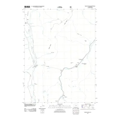
2011 Map of Boston Peak
USGS Topo · Published 2011About this map
Green Ridge separates two major water systems in this high-altitude landscape where the Laramie River and the Cache la Poudre River define the local geography. The engineering of the Laramie Poudre Tunnel illustrates a significant historical effort to move water beneath the divide, a critical component of Colorado's mountain water management. Around the small settlement of Spencer Heights, activity centers on a Trading Post and the Sportsman Lodge, catering to travelers along the river corridor.
Find a feature on this map
44 named features on this map. Tap any name to fly to it.
Don’t see what you’re looking for? This feature index may not catch every label — zoom into the map to look around manually.
Map Details
Editions of this 2011 Boston Peak Map
This is the sole edition of this map. No revisions or reprints were ever made.
Other maps of this area

1916 · Home
USGS Topo · 1:125,000

1920 · Home
USGS Topo · 1:125,000

1954 · Greeley
USGS Topo · 1:250,000

1957 · Greeley
USGS Topo · 1:250,000

1958 · Greeley
USGS Topo · 1:250,000

1961 · Greeley
USGS Topo · 1:250,000
1962 · Clark Peak
USGS Topo · 1:24,000

1962 · Boston Peak
USGS Topo · 1:24,000
1962 · Comanche Peak
USGS Topo · 1:24,000

1962 · Kinikinik
USGS Topo · 1:24,000