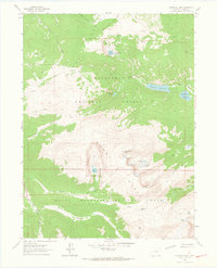
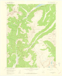
1962 Map of Comanche Peak
USGS Topo · Published 1964About this map
Mummy Range peaks and glacial basins define this early 1960s survey of the high country where Roosevelt National Forest meets Rocky Mountain National Park. The landscape is a network of alpine hydrology, featuring significant water bodies such as Comanche Reservoir, Hourglass Reservoir, and Browns Lake. The map reveals a remote wilderness infrastructure of high-altitude paths, including the Mummy Pass Trail, Zimmerman Trail, and Flowers Trail, which connect isolated features like the Cabin near Dadd Gulch. From the summit of Comanche Peak to the headwaters of the South Fork Cache la Poudre River, the sheet documents a preserved mountain environment before the intensification of modern recreational use, capturing the exact placement of high-country passes like Mummy Pass and Icefield Pass.
Find a feature on this map
33 named features on this map. Tap any name to fly to it.
Don’t see what you’re looking for? This feature index may not catch every label — zoom into the map to look around manually.
Map Details
Editions of this 1962 Comanche Peak Map
4 editions found
Other maps of this area

1915 · Longs Peak
USGS Topo · 1:125,000

1916 · Home
USGS Topo · 1:125,000

1919 · Rocky Mountain National Park
USGS Topo · 1:125,000

1920 · Home
USGS Topo · 1:125,000

1954 · Greeley
USGS Topo · 1:250,000

1957 · Greeley
USGS Topo · 1:250,000

1957 · Trail Ridge
USGS Topo · 1:24,000

1957 · Estes Park
USGS Topo · 1:24,000

1958 · Greeley
USGS Topo · 1:250,000
1958 · Fall River Pass
USGS Topo · 1:24,000