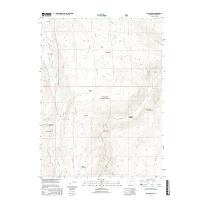
2016 Map of Boston Peak
USGS Topo · Published 2016About this map
Roosevelt National Forest spans this high-elevation terrain where the Medicine Bow Mountains and Mummy Range converge. The landscape is defined by the critical water infrastructure of the Laramie Poudre Tunnel, which diverts water from the Laramie River basin toward the Cache la Poudre River drainage. This 2016 survey captures the intersection of natural watercourses like Porter Creek and Nunn Creek with man-made diversions such as the Rawah and Enos Supply Ditch. Small settlements like Spencer Heights provide rare points of human habitation amid a wilderness marked by distinctive peaks like Sleeping Elephant Mountain and Boston Peak. The map provides an essential record of high-country access through forest roads like Green Ridge Road and recreational routes including the Zimmerman Trail and Roaring Creek Trail, illustrating how the region serves both as a resource for water management and as a mountain retreat.
Find a feature on this map
80 named features on this map. Tap any name to fly to it.
Don’t see what you’re looking for? This feature index may not catch every label — zoom into the map to look around manually.
Map Details
Editions of this 2016 Boston Peak Map
This is the sole edition of this map. No revisions or reprints were ever made.
Other maps of this area

1916 · Home
USGS Topo · 1:125,000

1920 · Home
USGS Topo · 1:125,000

1954 · Greeley
USGS Topo · 1:250,000

1957 · Greeley
USGS Topo · 1:250,000

1958 · Greeley
USGS Topo · 1:250,000

1961 · Greeley
USGS Topo · 1:250,000
1962 · Clark Peak
USGS Topo · 1:24,000

1962 · Boston Peak
USGS Topo · 1:24,000
1962 · Comanche Peak
USGS Topo · 1:24,000

1962 · Kinikinik
USGS Topo · 1:24,000