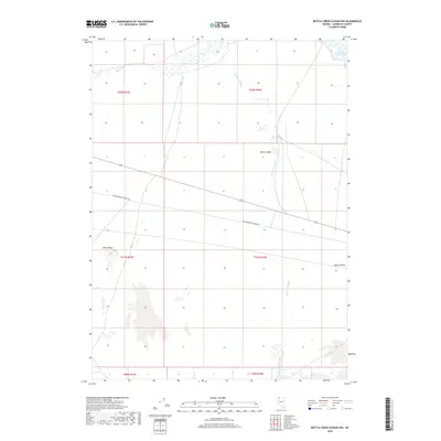
2018 Map of Bottle Creek Slough NW
USGS Topo · Published 2018About this map
Desert Valley dominates the high-desert landscape of this corner of Humboldt County, where the seasonal flow of the Quinn River defines the survival of the land. In the northern reaches, the Quinn River Lakes form a significant wetland complex, a vital contrast to the arid surroundings. The terrain is marked by the distinct Black Butte, providing a rare vertical landmark in a region characterized by wide flats and ephemeral watercourses. A long-standing transportation corridor is represented by the Old Winnemucca-Denio Rd, which cuts across the valley floor. The map also traces the winding path of Bottle Creek Slough, illustrating how water moves through this part of the Great Basin when the winter snowpack from distant ranges finally reaches the basin floor. This detailed survey preserves the hydraulic and topographical patterns of a remote Nevada wilderness before modern shifts in land use or water management.
Find a feature on this map
13 named features on this map. Tap any name to fly to it.
Don’t see what you’re looking for? This feature index may not catch every label — zoom into the map to look around manually.
Map Details
Editions of this 2018 Bottle Creek Slough NW Map
This is the sole edition of this map. No revisions or reprints were ever made.
Other maps of this area

1886 · Disaster
USGS Topo · 1:250,000

1893 · Disaster
USGS Topo · 1:250,000

1954 · Vya
USGS Topo · 1:250,000

1958 · Vya
USGS Topo · 1:250,000

1961 · Quinn River Crossing
USGS Topo · 1:62,500

1961 · Thacker Pass
USGS Topo · 1:62,500

1961 · Bottle Creek
USGS Topo · 1:62,500

1962 · Vya
USGS Topo · 1:250,000

1979 · Denio
USGS Topo · 1:100,000
1982 · Bottle Creek Slough SW
USGS Topo · 1:24,000