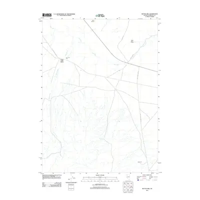
2011 Map of Bottle Hill
USGS Topo · Published 2011About this map
Happy Creek Station and Happy Creek Ranch anchor this high desert landscape, where the seasonal waters of the Quinn River and Happy Creek dictate the patterns of human settlement. The 2011 survey reveals an area defined by long-distance transit and ranching infrastructure, located at the intersection of several notable regional thoroughfares. The Old Winnemucca Denio Rd and Sand Pass Rd cut across the arid terrain, connecting remote outposts like Kings River Valley to the broader Great Basin network.
Find a feature on this map
12 named features on this map. Tap any name to fly to it.
Don’t see what you’re looking for? This feature index may not catch every label — zoom into the map to look around manually.
Map Details
Editions of this 2011 Bottle Hill Map
This is the sole edition of this map. No revisions or reprints were ever made.
Other maps of this area

1886 · Disaster
USGS Topo · 1:250,000

1893 · Disaster
USGS Topo · 1:250,000

1954 · Vya
USGS Topo · 1:250,000

1958 · Vya
USGS Topo · 1:250,000

1961 · Quinn River Crossing
USGS Topo · 1:62,500

1961 · Thacker Pass
USGS Topo · 1:62,500

1961 · Bottle Creek
USGS Topo · 1:62,500

1962 · Vya
USGS Topo · 1:250,000

1979 · Denio
USGS Topo · 1:100,000
1982 · Bottle Creek Slough SW
USGS Topo · 1:24,000