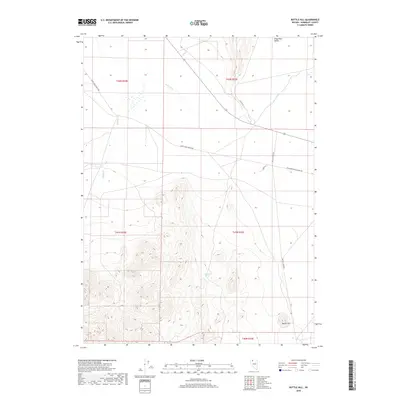
2018 Map of Bottle Hill
USGS Topo · Published 2018About this map
Kings River Valley serves as the backdrop for this high-desert landscape in northern Nevada, where the sparse network of ranching roads reflects the vast distances between remote outposts. The Quinn River meanders across the northern plains, a critical water source in an arid environment punctuated by isolated water points like Buckbrush Spring and the drainage of Happy Cr. Historically significant routes, including the Old Winnemucca-Denio Rd, trace the flatlands and provide a sense of the region's connectivity before modern highway improvements. The topography shifts dramatically at Coyote Pt and toward the namesake Bottle Hill in the southeast corner, where the rising elevation breaks the valley floor. These landforms and the presence of the Happy Creek Ranch Rd suggest a landscape defined by long-standing livestock operations and the survival of early desert corridors.
Find a feature on this map
15 named features on this map. Tap any name to fly to it.
Don’t see what you’re looking for? This feature index may not catch every label — zoom into the map to look around manually.
Map Details
Editions of this 2018 Bottle Hill Map
This is the sole edition of this map. No revisions or reprints were ever made.
Other maps of this area

1886 · Disaster
USGS Topo · 1:250,000

1893 · Disaster
USGS Topo · 1:250,000

1954 · Vya
USGS Topo · 1:250,000

1958 · Vya
USGS Topo · 1:250,000

1961 · Quinn River Crossing
USGS Topo · 1:62,500

1961 · Thacker Pass
USGS Topo · 1:62,500

1961 · Bottle Creek
USGS Topo · 1:62,500

1962 · Vya
USGS Topo · 1:250,000

1979 · Denio
USGS Topo · 1:100,000
1982 · Bottle Creek Slough SW
USGS Topo · 1:24,000