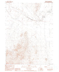
1990 Map of Bottle Hill
USGS Topo · Published 1990About this map
The Fort Mc Dermitt Indian Reservation stretches across the northern portion of this terrain, where the Quinn River meanders through the high desert landscape. The presence of the Niebuhr Mine and various Prospects in the southern hills indicates a focus on mineral extraction during this period. The landscape is characterized by wide-open spaces like Desert Valley, punctuated by isolated water sources such as Buckbrush Spring and Happy Creek. Human activity is primarily centered around the Happy Creek Ranch and localized industrial operations including a Gravel Pit and Quarry. A prominent Transmission Line and a network of 4wd tracks provide the primary infrastructure through the valley floor, connecting the base of Bottle Hill to the surrounding drainage of the Kings River.
Find a feature on this map
18 named features on this map. Tap any name to fly to it.
Don’t see what you’re looking for? This feature index may not catch every label — zoom into the map to look around manually.
Map Details
Editions of this 1990 Bottle Hill Map
This is the sole edition of this map. No revisions or reprints were ever made.
Other maps of this area

1886 · Disaster
USGS Topo · 1:250,000

1893 · Disaster
USGS Topo · 1:250,000

1954 · Vya
USGS Topo · 1:250,000

1958 · Vya
USGS Topo · 1:250,000

1961 · Quinn River Crossing
USGS Topo · 1:62,500

1961 · Thacker Pass
USGS Topo · 1:62,500

1961 · Bottle Creek
USGS Topo · 1:62,500

1962 · Vya
USGS Topo · 1:250,000

1979 · Denio
USGS Topo · 1:100,000
1982 · Bottle Creek Slough SW
USGS Topo · 1:24,000