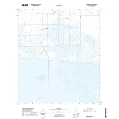
2018 Map of Boudreaux Lake
USGS Topo · Published 2018About this map
Gibbstown serves as a small focal point in this coastal Louisiana landscape, situated where La 27 crosses the expansive Intracoastal Waterway. The map captures a region defined by its water-dominant geography, featuring the broad expanse of Boudreaux Lake and the marshy edges of Sweet Lake. The transition from land to water is marked by distinctive terrain features like Savanne Neuville Island and the meandering East Prong of Grand Bayou. Local infrastructure supports both transit and industry, seen in the path of Conoco Plant Rd and the straight-line drainage of the North Canal. For genealogists and local historians, the Granger Cem on Grangerville Rd provides a specific point of reference for family research in this part of Cameron Parish. The interplay of parish roads and modern waterways illustrates the balance between historical settlement patterns and the managed water systems of the early 21st century.
Find a feature on this map
17 named features on this map. Tap any name to fly to it.
Don’t see what you’re looking for? This feature index may not catch every label — zoom into the map to look around manually.
Map Details
Editions of this 2018 Boudreaux Lake Map
This is the sole edition of this map. No revisions or reprints were ever made.
Other maps of this area

1932 · Lake Charles SW
USGS Topo · 1:31,680

1932 · Lake Charles SE
USGS Topo · 1:31,680

1934 · Lake Misere
USGS Topo · 1:24,000

1934 · Sweet Lake
USGS Topo · 1:24,000

1934 · Grand Bayou
USGS Topo · 1:24,000

1934 · Boudreaux Lake
USGS Topo · 1:24,000

1935 · Sweet Lake
USGS Topo · 1:31,680

1935 · Lake Misere
USGS Topo · 1:31,680

1935 · Boudreaux Lake
USGS Topo · 1:31,680

1935 · Grand Bayou
USGS Topo · 1:31,680