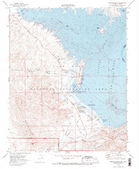
1970 Map of Boulder Beach
USGS Topo · Published 1973About this map
The Lake Mead National Recreation Area serves as the focal point for this 1970s topographical study, documenting a landscape shaped by water management and desert recreation. Significant infrastructure is evident in the Alfred Merritt Smith Water Treatment Plant, various pumping stations, and the Main Aqueduct snaking through the River Mountains. These features highlight the complex engineering required to support the region's growth and utility needs.
Find a feature on this map
41 named features on this map. Tap any name to fly to it.
Don’t see what you’re looking for? This feature index may not catch every label — zoom into the map to look around manually.
Map Details
Editions of this 1970 Boulder Beach Map
2 editions found
Other maps of this area

1886 · Camp Mohave
USGS Topo · 1:250,000

1886 · Saint Thomas
USGS Topo · 1:250,000

1892 · Camp Mohave
USGS Topo · 1:250,000

1893 · Saint Thomas
USGS Topo · 1:250,000

1926 · Nelson
USGS Topo · 1:96,000

1926 · Boulder Canyon
USGS Topo · 1:96,000

1942 · Camp Mohave
USGS Topo · 1:250,000

1947 · Kingman
USGS Topo · 1:250,000

1948 · Kingman
USGS Topo · 1:250,000

1952 · Henderson
USGS Topo · 1:62,500