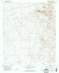
1970 Map of Boundary Cone
USGS Topo · Published 1986About this map
Boundary Cone rises as a prominent landmark in the Black Mountains of Mohave County, serving as the focal point for an area defined by its late-century mining activity. This 1970 survey records a landscape etched with the legacy of resource extraction, where numerous claims such as the United Oatman Mine, Alcyone Mine, and Black Range Mine are connected by a network of Jeep Trails. The concentration of these sites around the foothills of Wrigley Peak and McHeffy Butte illustrates the intense geological interest in the region. Beyond the shafts and tunnels of the Oatman Southern Mine and Adams Mine, the map documents modern infrastructure developments, including a prominent Pipeline and a Borrow Pit north of the volcanic heights.
Find a feature on this map
20 named features on this map. Tap any name to fly to it.
Don’t see what you’re looking for? This feature index may not catch every label — zoom into the map to look around manually.
Map Details
Editions of this 1970 Boundary Cone Map
3 editions found
Other maps of this area

1886 · Camp Mohave
USGS Topo · 1:250,000

1892 · Camp Mohave
USGS Topo · 1:250,000

1903 · Needles
USGS Topo · 1:125,000

1904 · Needles Special
USGS Topo · 1:125,000

1926 · Mohave City
USGS Topo · 1:96,000

1942 · Camp Mohave
USGS Topo · 1:250,000

1947 · Kingman
USGS Topo · 1:250,000

1948 · Kingman
USGS Topo · 1:250,000

1950 · Davis Dam
USGS Topo · 1:62,500

1950 · Needles
USGS Topo · 1:62,500