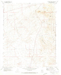
1970 Map of Boundary Cone
USGS Topo · Published 1973About this map
The Black Mountains dominate this portion of Mohave County, where the desert landscape is defined by its deep mining history and high-relief volcanic topography. Landmarks like Boundary Cone and McHeffy Butte anchor the horizon, while the terrain is marked by an extensive network of mineral exploration sites. This late 1960s survey reveals the scale of the Oatman mining district's influence, with specialized operations including the United Oatman Mine, Oatman Southern Mine, and Oatman Syndicate Mine spread across the slopes. The concentration of claims such as the Green Quartz Mine and Black Range Mine suggests a period of transition between active production and the preservation of historic lodes. Outside of these industrial nodes, the land remains largely untracked, save for a prominent Pipeline and a series of Jeep Trails that provide the only access to remote heights like Wrigley Peak.
Find a feature on this map
19 named features on this map. Tap any name to fly to it.
Don’t see what you’re looking for? This feature index may not catch every label — zoom into the map to look around manually.
Map Details
Editions of this 1970 Boundary Cone Map
3 editions found
Other maps of this area

1886 · Camp Mohave
USGS Topo · 1:250,000

1892 · Camp Mohave
USGS Topo · 1:250,000

1903 · Needles
USGS Topo · 1:125,000

1904 · Needles Special
USGS Topo · 1:125,000

1926 · Mohave City
USGS Topo · 1:96,000

1942 · Camp Mohave
USGS Topo · 1:250,000

1947 · Kingman
USGS Topo · 1:250,000

1948 · Kingman
USGS Topo · 1:250,000

1950 · Davis Dam
USGS Topo · 1:62,500

1950 · Needles
USGS Topo · 1:62,500