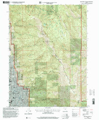
1998 Map of Bountiful Peak
USGS Topo · Published 2001About this map
Bountiful Peak stands as the central landmark of this mountain landscape, overlooking the rapidly developing corridor along the eastern shore of the Great Salt Lake. The late 20th-century expansion of Bountiful and Centerville is clearly visible, with residential streets climbing the foothills toward the Bonneville Shoreline Trail. This interface between urban growth and the Wasatch National Forest is defined by a series of steep canyons, including Holbrook Canyon, Ward Canyon, and Parrish Creek, which have historically shaped the settlement patterns of Davis County. Significant community infrastructure is present, from the LDS Temple and Lakeview Hospital to numerous local schools like Bountiful High Sch. Higher elevations are characterized by recreational and forestry use, marked by the winding Skyline Drive and the Morris Creek Research Natural Area.
Find a feature on this map
55 named features on this map. Tap any name to fly to it.
Don’t see what you’re looking for? This feature index may not catch every label — zoom into the map to look around manually.
Map Details
Editions of this 1998 Bountiful Peak Map
This is the sole edition of this map. No revisions or reprints were ever made.
Other maps of this area

1885 · Salt Lake
USGS Topo · 1:250,000

1925 · Ft. Douglas
USGS Topo · 1:125,000

1928 · Ft. Douglas
USGS Topo · 1:125,000

1950 · Fort Douglas
USGS Topo · 1:24,000

1951 · Fort Douglas
USGS Topo · 1:24,000

1951 · Salt Lake City North
USGS Topo · 1:24,000

1952 · Farmington
USGS Topo · 1:24,000

1952 · Bountiful Peak
USGS Topo · 1:24,000

1954 · Salt Lake City
USGS Topo · 1:250,000

1954 · Ogden
USGS Topo · 1:250,000