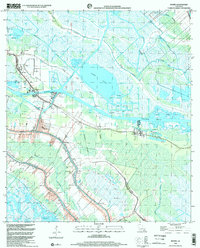
1998 Map of Bourg
USGS Topo · Published 2003About this map
Bourg and the surrounding marshlands of Terrebonne Parish are defined by the convergence of industrial energy extraction and historic bayou settlements. This 1998 survey illustrates a landscape intricately carved by the Intracoastal Waterway and various navigation channels like the Hollywood Canal and Lake Long Company Canal. The region's economy is clearly anchored by the Bourg Gas Field and the Lake Long Oil and Gas Field, with numerous drill holes dotting the wetlands. Family history and community life are marked by landmarks such as Matherne Cem, St Elie Cem, and Bisland Cem, alongside local spiritual centers like St Peters Ch and the Charpentier Mission. The map captures the complex drainage and transportation network where Bayou Terrebonne and Bayou Petit Caillou meander through the low-lying terrain.
Find a feature on this map
32 named features on this map. Tap any name to fly to it.
Don’t see what you’re looking for? This feature index may not catch every label — zoom into the map to look around manually.
Map Details
Editions of this 1998 Bourg Map
This is the sole edition of this map. No revisions or reprints were ever made.
Other maps of this area

1892 · Cut-Off
USGS Topo · 1:62,500

1892 · Houma
USGS Topo · 1:62,500

1894 · Lake Felicity
USGS Topo · 1:62,500

1894 · Dulac
USGS Topo · 1:62,500

1932 · Houma SE
USGS Topo · 1:31,680

1932 · Houma SW
USGS Topo · 1:31,680

1932 · Houma NE
USGS Topo · 1:31,680

1932 · Houma NW
USGS Topo · 1:31,680

1935 · Viguerie Canal
USGS Topo · 1:31,680

1935 · Montegut
USGS Topo · 1:31,680