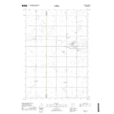
2017 Map of Bowdle
USGS Topo · Published 2017About this map
Bowdle serves as the central hub of this prairie landscape, where the grid of the town site meets the expansive agricultural reaches of Walworth and Edmunds counties. The town's layout is meticulously detailed, showing the concentration of civic and spiritual life at the intersection of Main St and 2nd St. The surrounding countryside is dotted with small, family-named and denominational cemeteries, including Nell Glueckstal Cem and Ketterling Cem, which speak to the deep-rooted settlement patterns of the early twentieth century. Further south, the intermittent drainage of Swan Lake Cr meanders through the township, reflecting the subtle hydrology of the region. This 2017 update documents the persistent character of a Great Plains community, including landmarks like the Bowdle Municipal Airport and long-standing religious institutions such as Saint John church.
Find a feature on this map
34 named features on this map. Tap any name to fly to it.
Don’t see what you’re looking for? This feature index may not catch every label — zoom into the map to look around manually.
Map Details
Editions of this 2017 Bowdle Map
This is the sole edition of this map. No revisions or reprints were ever made.
Other maps of this area
1954 · Aberdeen
USGS Topo · 1:250,000
1956 · Aberdeen
USGS Topo · 1:250,000
1974 · Gretna
USGS Topo · 1:24,000
1974 · Hoven Muni. Airport
USGS Topo · 1:24,000
1974 · Spring Lake
USGS Topo · 1:24,000
1974 · Bowdle SE
USGS Topo · 1:24,000
1974 · Bowdle
USGS Topo · 1:24,000
1978 · Hillsview SE
USGS Topo · 1:24,000
1978 · Bowdle SW
USGS Topo · 1:24,000
1978 · Bowdle-Hosmer Lake
USGS Topo · 1:24,000