
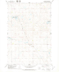
1978 Map of Bowdle-Hosmer Lake
USGS Topo · Published 1979About this map
Glacial potholes and prairie wetlands define the landscape of the Modena and Bowdle regions, where the late 1970s topography reveals an intricate system of water bodies and conservation lands. The central feature, Bowdle-Hosmer Lake, is surrounded by managed habitats including the Bowdle-Hosmer Public Shooting Area and the South Jackson Public Shooting Area. These protected zones, alongside the National Waterfowl Production Area, indicate a geography heavily shaped by the preservation of migratory bird corridors.
Find a feature on this map
16 named features on this map. Tap any name to fly to it.
Don’t see what you’re looking for? This feature index may not catch every label — zoom into the map to look around manually.
Map Details
Editions of this 1978 Bowdle-Hosmer Lake Map
This is the sole edition of this map. No revisions or reprints were ever made.
Other maps of this area

1954 · Aberdeen
USGS Topo · 1:250,000

1956 · Aberdeen
USGS Topo · 1:250,000

1974 · Gretna
USGS Topo · 1:24,000

1974 · Spring Lake
USGS Topo · 1:24,000

1974 · Bowdle
USGS Topo · 1:24,000

1978 · Hillsview SE
USGS Topo · 1:24,000

1978 · Java SE
USGS Topo · 1:24,000

1978 · Flat Lake
USGS Topo · 1:24,000

1978 · Feinstein Lake
USGS Topo · 1:24,000
1978 · Hillsview
USGS Topo · 1:24,000