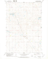
1978 Map of Hillsview
USGS Topo · Published 1979About this map
Hillsview sits at the heart of this McPherson County landscape, a small prairie settlement defined by its position along the Chicago Milwaukee St Paul and Pacific railroad. The surrounding terrain is a mosaic of small glacial potholes and wetlands, highlighted by several designated National Waterfowl Production Areas that emphasize the region's importance for migratory birds. Evidence of local industry and infrastructure appears in the scattered Gravel Pits and the presence of a Flowing Well near the rail line. To the south of the main town site, the St Joseph Cem provides a focal point for genealogical interest, marking the enduring presence of the local community amidst the vast agricultural stretches of the Dakotas in the late 1970s.
Find a feature on this map
7 named features on this map. Tap any name to fly to it.
Don’t see what you’re looking for? This feature index may not catch every label — zoom into the map to look around manually.
Map Details
Editions of this 1978 Hillsview Map
This is the sole edition of this map. No revisions or reprints were ever made.
Other maps of this area

1954 · Aberdeen
USGS Topo · 1:250,000

1956 · Aberdeen
USGS Topo · 1:250,000

1978 · Hillsview SE
USGS Topo · 1:24,000

1978 · Hosmer NW
USGS Topo · 1:24,000

1978 · Bowdle-Hosmer Lake
USGS Topo · 1:24,000

1978 · Eureka West
USGS Topo · 1:24,000

1978 · Feinstein Lake
USGS Topo · 1:24,000

1978 · Eureka East
USGS Topo · 1:24,000

1978 · Hosmer
USGS Topo · 1:24,000

1978 · Schumacher Lake SW
USGS Topo · 1:24,000