
1978 Map of Hosmer
USGS Topo · Published 1979About this map
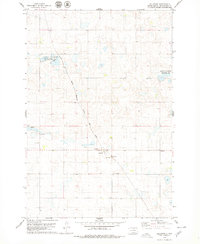
Hosmer serves as the primary hub in this late 1970s survey, straddling the northern prairie landscape along the Chicago Milwaukee St Paul and Pacific railroad line. The settlement layout is clearly defined, featuring a local Park and a dedicated Cemetery within its borders. To the west, the Holy Trinity Cemetery stands separately, providing a specific focal point for genealogical research in this rural corridor. The terrain is characterized by numerous small depressions and basins, a common glacial feature of the region, interspersed with townships like Sangamon and Glen. Industrial activity is marked by various Gravel Pits scattered near the rail line, indicating the importance of local material extraction. The southern portion of the quadrangle is defined by the northern reaches of Cottonwood Lake, while the county boundary between McPherson and Edmunds counties bisects the township range north of town.
Find a feature on this map
14 named features on this map. Tap any name to fly to it.
Don’t see what you’re looking for? This feature index may not catch every label — zoom into the map to look around manually.
Map Details
Editions of this 1978 Hosmer Map
This is the sole edition of this map. No revisions or reprints were ever made.
Other maps of this area

1954 · Aberdeen
USGS Topo · 1:250,000

1956 · Aberdeen
USGS Topo · 1:250,000

1974 · Gretna
USGS Topo · 1:24,000

1974 · Roscoe
USGS Topo · 1:24,000

1978 · Hillsview SE
USGS Topo · 1:24,000

1978 · Roscoe NW
USGS Topo · 1:24,000

1978 · Hosmer NW
USGS Topo · 1:24,000

1978 · Hosmer NE
USGS Topo · 1:24,000

1978 · Hosmer SE
USGS Topo · 1:24,000
1978 · Hillsview
USGS Topo · 1:24,000