
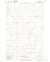
1978 Map of Hosmer NE
USGS Topo · Published 1979About this map
Glacial depressions and small water bodies dominate this McPherson County landscape, which is largely dedicated to conservation and seasonal land use. Public lands define the northeastern quadrant, including the Moscow State Public Shooting Area and a National Waterfowl Production Area, reflecting the region's importance to the Central Flyway. Human settlement is sparse and primarily agricultural, anchored by the presence of the Lutheran Cem and Congregational Cem, which serve as quiet markers of the community's ancestral ties. Small-scale resource extraction is visible through scattered Gravel Pits and a lone Gravel Pit to the south. The terrain's character is further evidenced by a singular Well near the southwestern corner, indicating the necessity of managed water access in this prairie environment.
Find a feature on this map
9 named features on this map. Tap any name to fly to it.
Don’t see what you’re looking for? This feature index may not catch every label — zoom into the map to look around manually.
Map Details
Editions of this 1978 Hosmer NE Map
This is the sole edition of this map. No revisions or reprints were ever made.
Other maps of this area

1954 · Aberdeen
USGS Topo · 1:250,000

1956 · Aberdeen
USGS Topo · 1:250,000

1968 · Long Lake
USGS Topo · 1:24,000

1978 · Hosmer NW
USGS Topo · 1:24,000

1978 · Hosmer SE
USGS Topo · 1:24,000

1978 · Hosmer
USGS Topo · 1:24,000

1978 · Schumacher Lake
USGS Topo · 1:24,000

1978 · Schumacher Lake SW
USGS Topo · 1:24,000

1978 · Plainview Colony NW
USGS Topo · 1:24,000
1978 · Plainview Colony SW
USGS Topo · 1:24,000