
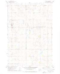
1974 Map of Bowdle SE
USGS Topo · Published 1978About this map
Odessa, Cloyd Valley, Hudson, and Madison townships define the human geography of this 1974 survey. This area of central South Dakota is characterized by a high density of small depressional wetlands and potholes, many of which are protected within the National Waterfowl Production Area. The landscape is fundamentally agricultural, organized by the rectangular township and range system with section lines often serving as the primary road network. Human activity is evidenced by scattered farmsteads and localized Gravel Pits. Conservation and recreation are significant land uses, notably at the Steigelmeier State Public Shooting Area, where the prairie environment is managed for wildlife habitat. The reliance on subterranean water sources is noted by various Well locations across the plains, which support both livestock and domestic needs in this semi-arid region.
Find a feature on this map
10 named features on this map. Tap any name to fly to it.
Don’t see what you’re looking for? This feature index may not catch every label — zoom into the map to look around manually.
Map Details
Editions of this 1974 Bowdle SE Map
This is the sole edition of this map. No revisions or reprints were ever made.
Other maps of this area

1950 · Onaka
USGS Topo · 1:24,000

1952 · Onaka
USGS Topo · 1:24,000

1954 · Aberdeen
USGS Topo · 1:250,000

1956 · Aberdeen
USGS Topo · 1:250,000

1965 · Onaka
USGS Topo · 1:24,000

1974 · Gretna
USGS Topo · 1:24,000

1974 · Roscoe SW
USGS Topo · 1:24,000

1974 · Bowdle
USGS Topo · 1:24,000
1978 · Tolstoy
USGS Topo · 1:24,000

1978 · Seneca NW
USGS Topo · 1:24,000